How to convert coordinates from one number format to another
Geographic coordinates of the same point can be expressed in different formats. Depending on whether minutes and seconds are represented as values from 0 to 60 or from 0 to 100 (decimals).
The coordinate format is usually written as follows: DD - degrees, MM - minutes, SS - seconds; if minutes and seconds are presented as decimals, then simply write DD.DDDD. For example:
DD MM SS: 50° 40" 45"" E, 40 50" 30"" N. - Degrees, minutes, seconds
DD MM.MM: 50° 40.75" E, 40 50.5" N - Degrees, decimal minutes
DD.DDDDD: 50.67916 E, 40.841666 N - Decimal degrees.
Many programs do not understand coordinates expressed in a form that allows spaces, such as DD MM SS or DD MM.MM. For normal operation, it is recommended to store coordinates in the form DD.DDDDD.
There are many ways to carry out this conversion, let's consider 3 main ones (in order of effectiveness).
Set up GPS correctly
In order to avoid problems with coordinate translation, the easiest way is to immediately configure the GPS so that it displays coordinate values in the format DD.DDDDD. However, this may not be convenient for those who navigate the field using topographic maps with a coordinate grid, where the coordinates are signed in a different numerical format. On the other hand, in this case, it is recommended to sign the coordinate grid itself in this format.
Use a special script
If you are working in Arcview GIS, you can use a special script that will perform the recalculation for you.
To start working in Arcview, a table in DBF format must be created or loaded (you can create such a table, for example, in Excel). A table in which the initial values are recorded MUST be open for recording Table\Start editing.
This table must contain 2 columns (the total number may be more) in which coordinate values must be written in the format DDMMSS that is, there should be no spaces between the numbers, for example 505050.3214
During operation, the script will ask you to specify the name of the column in which the latitude values are recorded and the column in which the longitude values are recorded. It will then ask you to enter a name for the resulting columns. After this, the script will perform the transformation and write coordinate values in the format in new columns with the names that you entered DD.DDDDD.
Recalculate coordinate values yourself in Excel
Formula for converting from dd mm ss to dd.ddddd:
Formula for converting from dd mm.mmmm to dd.ddddd:
Formula for converting from dd.ddddd to dd mm ss:
DD = TRUNC(DDD)
MM = TRUNC((DDD − DD) * 60)
SS = ((DDD − DD) * 60 − MM) * 60
where DDD - coordinates in DD.DDDD format, DD - degrees, MM (MM.MMMM) - minutes, SS - seconds
If you are too lazy to enter formulas and create a table, you can download a ready-made one. Then you only need to enter your coordinates and copy the columns with the results and paste them into a new table or text file, which can then be imported into the GIS.
To make recalculating coordinates in Excel even easier, you can use an add-in that connects to Excel. After connecting it, several formulas are added to Excel that allow you to convert values from DDMMSS (in different formats to decimal degrees). Download the add-on. Description of connecting and using the add-on inside the archive.
- GRD__GG_MMSS - conversion of degrees entered into 1 cell in the form GG,MMSS
- GRD__YYMM_SS - conversion of degrees entered into 1 cell in the form YYMM,SS
- GRD__YY_MM_SS - conversion of degrees entered into 3 cells in the form GG MM SS
About 10 days ago I met Volodya, RW9AW, on air on channel 20. Less than two weeks have passed since he and his son Ivan UA9AGR are in my kitchen! It turned out that both are avid travelers and on the way they managed to visit Sasha R1NA :-) But I’m talking a little about something else. I'm talking about the Slavs from the former USSR. If this were in prim Europe, then there would have been negotiations for a month about the date of arrival, visas, hotel, currency of payment for transport services, what flag to hang at the airport on the day of arrival and other protocol nuances. Everything is simpler here: the main thing is that you don’t leave home that day :-)  Upon arrival, tea with cocoa, help for Volodya, who was wounded on the road (by the way, he brought the “wound” - a stubbed toe from Karelia - the stairs at R1NA are steep :-) One must think that the vodka was strong :-) It turned out that the general history for 70 years still will make itself felt for a long time: we understand each other at a glance, words from the “Soviet” vocabulary that have now come out of obscurity, quotes from Vysotsky (from Pushkin, by the way, too, although the current generation knows him approximately as the work of Byron). And at the same time there is a lot of new things: first-hand information about the Chelyabinsk meteorite,
Contest: tactics and practice
Here. I drank coffee and was curious about how the contest went for others. There is a lot of interesting things, although the contest itself is already traditional and its position does not quite keep up with the times. The fact that there are not enough correspondents for a full-fledged contest, unfortunately, has been no secret for several years. I already wrote about this and provided graphs. :-) Half an hour after the start of the tour there is no one to work with, the logger is cursing and even a very careful listening of the range does not add new correspondents, not to mention the pace of connections. Since I am not too keen on obtaining sports ranks (it must be admitted that this is an exception that contradicts the very meaning of the competition :-) I did not pay attention to the aspect of the unattractiveness of the contest in this sense. Alexey UT0RM brought this to my attention. In order not to be branded as a phone that doesn’t quite work, I’ll just quote:
"Egor, greetings!
As you know, I didn’t take part, but I listened to the test for almost two hours. I didn’t notice anything new or interesting for myself in the test. Although, in fairness, I note that people have completely changed the keys to the keyboard. Well, that's how it should have been. Only a retrograde or lazy person doesn’t see the point in this. The test itself is the same as always, there are few participants, no pace. You and many others had to squirm into the void, which probably didn’t bring much pleasure. My firm opinion is that the championship in the form in which it is held has long outlived its usefulness, or maybe the reason is deeper. Well I do not know. But I was not interested in such a test. P.S. I posted a screenshot of the championship participants"
CQ: Happy New Year!
Another year has flown by. The granddaughter has grown so much that she already understands what nature conservation means: her New Year’s work for the environmentalist competition does not contain a single broken spruce or pine branch. Perhaps the hands are twigs, but they are raised from the ground.

Happy New Year 2019 to everyone! I wish everyone, without exception, happiness in the New Year, so that problems go away, and joy (and money :-) never stop coming. To be loved by your loved ones and respected by everyone else. I wish that, in addition to personal happiness and the well-being of your families, this year you get all the DX, confirm all the countries missing from your DXCC 9B, take places in competitions that you think deserve, get a lot of pleasure from communicating at our round tables and meet familiar call signs more often on the bands! 73!
Progress is coming
 It has been no secret for a couple of years now that SDR technologies are increasingly replacing traditional radio technology in transceiver housings. After several “sighting” options, as a result of the rapid development of transceiver software, almost complete SDR transceivers appear. It turns out that they are much more convenient than traditional ones. A “feature” that migrated from the field of mobile communications turned out to be especially convenient - the touchpad. As a person under 25 years old would put it - “crap” :-) Just admire it.
HF SVD

:-) Only Russians will understand this abbreviation....
In fact, everyone guessed that the photo shows a broadband log-periodic 18-element antenna. Of course, on the low frequency ranges with special tricks, but it works from 1 to 30 MHz (if not better). I can only go by my own experience - on the way to work I passed by the Nigerian embassy, there was one like this. Well, you could hear it sometimes... :-) A fairly common antenna for these purposes. Remember the movie "TASS is authorized to declare", Trianon. :-) So it's a really big antenna. I would say not even a rifle, but a howitzer :-)
Trying to show FunCube1
 On the Internet I found the most economical tool in terms of output file size to show you a video from the screen: how TV reception occurs with FunCube-1. But it turned out that Windows protection blocks the EXE file in half the cases :-) So those who are braver and have not closed themselves tightly with a firewall can try to see how packets are received from the now beloved cubesatik. The file also contains a “canned” player :-)
Here is a short one (forgot the sound:-) 3 MB and here is a normal one, with sound and two minutes http://ham.cn.ua/vhf/FunCube.exe
Diploma announced from satellite
 FUNCUBE-1
Freq 145930
khz Mode BPSK Report 339
FUNCUBE-1
Freq 145930
khz Mode BPSK Report 339
How useful it can be to watch satellites. Here is the news just now from the AO-73 FunCube-1 in the telemetry text:
04.10.2014 19:17:23, 229636, FM5, The 73 on 73 award is organized by Paul Stoetzer, N8HM. Further details at http://amsat-uk.org/2014/08/18/73-on-73-award-announcement/
And here, in fact, is the position: from Paul Stoitzer N8HM
I am pleased to announce that I am sponsoring a new reward to promote activism through AO-73 (FUNcube-1). The requirements for obtaining this diploma are very simple:
1. Operate 73 unique (call signs) stations on AO-73.
2. Contacts must be made after September 1, 2014.
3. There are no more requirements :-)
The award is free to you (due to contributions to AMSAT-UK. and the Fox AMSAT-NA program). No QSLs required. When you have completed the diploma requirements, send your application as a log extract, including the callsign of each station, type of operation, orbit number, UTC date and time on This email address is being protected from spambots. You must have JavaScript enabled to view it., as well as the address to which the diploma should be sent. Enjoy amateur radio Cosmos - the AO-73 transponder!
73 Paul Stoetzer, Washington N8HM, DC
Not everyone understands how, and most importantly, why, the conversion of familiar geographic coordinates into rectangular coordinates is done. This is caused by the problem that the spherical surface of our planet has to be transferred to the map plane, so distortions are inevitable.
It is much more convenient to look for the position of a point when a system of rectangular (linear) coordinates is used for a flat image. This type of calculus is otherwise called the Gauss-Kruger projection, since it was these two German scientists who developed it to correctly display the curved earth's surface on a map. In our country, it is still most applicable for military cartography, geodesy and engineering design. The use of a similar UTM coordinate system is popular among Western countries.
Algorithms for converting geographic coordinates to rectangular coordinates
To quickly convert geographic coordinates into rectilinear coordinates and vice versa, special algorithms are used, which have become the basis of automatic programs for such a service. Online converters have also been developed that recalculate both Gauss-Kruger and UTM coordinates, when the degree of location of an object, even its minute and second, are converted into exact meters - and vice versa, when meters are transformed into degrees.
The latitude and longitude parameters on which our object is located are entered into the program or converter, and the output has the following values: x(horizontal parameter) and y(vertical parameter). The reverse translation is done in the same way.
The conversion formula (key) takes into account:
- numbering of the zone according to Gauss-Kruger (out of the available 60);
- scale factor (for Gauss-Kruger it is one, for UTM it is 0.9996);
- trigonometric functions;
- initial parallel;
- axial meridian;
- major and minor axes;
- conditional displacements inherent in the initial parallel in the north, as well as the central meridian in the east;
- the amount of flatness;
- eccentricity.
GLONASS and GPS satellite navigation provide constant tracking of coordinates of any given format. You can set the values so that latitude and longitude are shown, and meters or kilometers are displayed at the same time.
By the way! For a long time, the USSR classified translation keys - they were issued by the military for geodesy upon special request.
What are rectangular coordinates
The basis for the projection of an ellipse onto a plane - either according to Gauss-Kruger or according to the UTM system - is the principle of Descartes' rectilinear calculus.
- Beyond the horizontal axis X the abscissa (parallel) going to the east is taken as the vertical Y- ordinate (meridian) going north, beyond the origin O- their intersection.
- A point marked on the map plane is measured by the vertical distance to the axis line X(this will be the value y), plus horizontal to the axis line Y(this will be the value x).
- The plane is divided by the axes into 4 parts - the so-called quadrants numbered counterclockwise (I, II, III, IV): I quadrant upper right (northeast), II upper left (northwest), III lower left (south-west). west), IV lower right (southeast).
The values have both a plus and a minus value, which depends on the position relative to the quadrant:
- Quadrant I has both positive values ( x, y);
- Quadrant II specifies mixed values (- x, y);
- Quadrant III has both negative values (- x,-y);
- The IV quadrant also has mixed values ( x,-y).
 Further, the systems have significant differences.
For the Gauss-Kruger projection, the territory displayed on the map is divided into 60 zones, where the distance between the meridians is equal to 6º. The countdown goes from Greenwich to the east and to the equator to the north. Unit is taken as the scale factor. The starting point is the intersection of the selected meridian with the equator.
The UTM system developed by the Americans is characterized by similar divisions into 60 zones, but the calculated meridian is different - the first zone by number starts from the meridian of 177º west longitude. The differences also relate to the scale factor - it is equal to 0.9996. There are no negative values in the UTM system - for this, 500 kilometers are added to the western abscissa, and 10 thousand kilometers to the southern ordinate.
Where are rectangular systems used?
Rectangular systems are relevant for small-scale maps, for coordination between rescuers and the military, for the field of military and geodetic cartography, in the design of objects on the territory, engineering work, and drawing up schematic designs.
But the main application is geodesy, army and navy. It was the armed forces of most states that switched to rectangular coordinates, marking military targets with them.
Data in the local coordinate system is very often used in the state real estate registry. So, based on exporting data from the cadastral plan of the territory to the GIS MAP, as is done in the article Converting xml extracts of Rosreestr, you can get an electronic map without set coordinate system parameters.
If you know the parameters of the local coordinate system, then they can be written in the electronic map passport. In our example, we use data in MSC-12 zone 2 for the territory of the Mari-Turek district of the Republic of Mari El, which are taken from the article MSC-12 Republic of Mari El parameters for mapinfow.prj. You can also take MSC parameters from the file Subjects of the Russian Federation.xml, located in the root of the folder of the installed version 11 of Panorama (GIS Map).
Let us immediately make a reservation that these parameters of the local coordinate system were obtained BY CALCULATION in a software environment by comparing the data of the Public Cadastral Map of Rosreestr (WHICH HAVE AN OBVIOUS SHIFT when openly published) and the data of cadastral plans (CPT) of territorial departments of cadastral chambers. Thus, these parameters require adjustment. This article only describes the procedure necessary to convert data from one coordinate system (local) to another system.

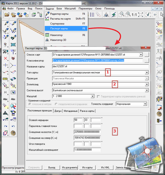
Stage 1. To configure the parameters of the coordinate system in the GIS MAP, select “Tasks/Map Passport” in the menu or press the F8 key, in the pop-up window you must select the appropriate: map type – 1; ellipsoid – 2; values of the axial meridian, offset to the east and north, rotation angle and scale factor - 3. Example line for Mapinfo:
"MSK-12 zone 2", 8, 1001, 7, 50.55, 0, 1, 2250000, -5914743.504.
The parameter designations in the line are presented for Mapinfo and GIS Map in the table below. These parameters can be written to an xml file for further use and quick installation of parameters from this file.

| Line options | Designation in Mapinfo | Passport Line GIS Map |
|---|---|---|
| "MSK 12 - zone 2" | SC title, “Projection Selection” | Map type – topographic universal local |
| 8 | projection type "Transverse Mercator" | Projection – Transveres Mercator |
| 1001 | region "Pulkovo 1942, Germany, Krassovsky" | Ellipsoid – Krasovsky 1940 |
| 7 | unit of measurement "meter" | |
| 50.55 | zero longitude "50 degrees 33 minutes" | Axial meridian - 50 degrees 33 minutes |
| 0 | zero latitude "0 degrees" | Parallel to the main point - skip |
| 1 | scale factor "1" | Scale factor – 1.000 |
| 2250000 | east offset "2250000 meters" | East offset – 2250000.00 |
| -5914743.504 | north offset "-5914743.504 meters" | North offset - -5914743.504 |
Stage 2. To convert MCS data to another coordinate system, you need to create a new map or open an existing map with the appropriate parameters, for example SK-95, as shown in the figure. The zone number for this area is 9.
Stage 3. Go to the map with MSK, select all map objects, and through the “Edit/Copy selected objects” menu, copy them to the clipboard. Next, go through the “window” menu to the map with SK-95 and through the “edit/insert map objects” menu, insert data that is automatically recalculated from MSC to SK-95.
For example (according to the standard Google service help), longitude, in one of the formats of the maps.google.ru service, is 41.40338° east longitude. In practice, in decimal fractions of geodetic degrees, five decimal places are enough, which corresponds to the maximum possible actual accuracy (up to several meters horizontally) of conventional satellite navigation devices intended for civilian users.Attention: The Panorama developers do not recommend this method of recalculation. It is better after stage 1 to launch through the “Tasks/Launch Applications” menu or the F12 button the application in the “Data (map) Conversion/Vector Map Conversion” tab, where the output parameters of the map are configured (on the right side of the window), which will be saved under the same name , same as the original map, but in the Modifi subfolder.
Then, the sequence of calculations is:
40338 / 100,000 = X / 60
X = (40338 * 60) / 100,000 ~ 24.2028 (from the proportion we find the numerator of the right fraction).
Whole minutes: 24"
2028 / 10,000 = X / 60
X = (2028 * 60) / 10,000 ~ 12.17
Seconds: 12.17"
Result: 41.40338° = 41° 24" 12.17" (forty-one degrees, twenty-four minutes, twelve point seven seconds).
Latitude is recalculated in the same sequence.
Google supports various angular data formats.
Examples of how to do it right
Abbreviated forms for recording geographic coordinates (north latitude, east longitude):
Degrees and, separated by a space, minutes with their decimals:
41 24.2028, 2 10.4418
Decimal degrees:
41.40338, 2.17403
The full form of writing an angle (degrees, minutes, seconds with their decimals):
41° 24" 12.1674", 2° 10" 26.508"
A simplified degree-minute version, which Google may be able to recognize if two pairs of numbers (integer degrees and minutes) separated by a comma are typed into the search line:
41 24, 2 10
The Googlemap service has an online converter for converting coordinates and converting them into the required format.
Online maps of various Internet services make it possible to set and receive location coordinates with an accuracy of six decimal places of degrees, after the decimal point, that is, up to a meter. This is enough to work together with modern car navigators and built-in mobile devices (smartphones, tablets and other gadgets) receivers of signals from the satellite global positioning system GLONASS (Russia), GPS (USA) and Beidou (China). Navigation devices for “civilian” users have a single measurement error of up to several meters (in the horizontal plane on the earth’s surface). Electronic digital data may vary significantly. Vector maps have significant advantages over raster formats: the ability to automatically search for information (by the name of a settlement, the characteristics of a geographical object) and quickly update to the current version, good readability when zooming in/out, layering thematic layers, obtaining a three-dimensional three-dimensional image, the ability overlaying scanned copies from paper materials, for example from Soviet topographic tablets.
The main forms of representing the values of geographical coordinates with an accuracy of a few meters:
degrees with hundred thousandths (YY.YYYYY°)
degrees, minutes with thousandths (GG° MM.MMM")
degrees, minutes, seconds with tenths (GG° MM" CC.S")
This number of decimal places corresponds to the order of the maximum possible accuracy of a single measurement of conventional GPS navigators, during their normal operation, under acceptable conditions (successful location of satellites in the sky, good level of satellite signal, etc.) With repeated measurements at a fixed point device, positioning accuracy, theoretically, should increase due to the collection of statistics to determine the mathematical average from a cloud of numerical values. But this does not make much sense if the original satellite signal is modified by software and contains an artificial error in the coordinates, which operators increase for ordinary consumers, for example, in wartime. In such cases, in selective access mode for civilian users, data distortions appear - the coordinate grid can be significantly shifted relative to the true position.
When specifying the coordinates of the search area, for example, if a tourist group is lost on the route, for search and rescue operations, the duty officer is informed of the estimated location of the missing, in the form of numbers:
GG° MM" CC" northern latitude, GG° MM" CC" eastern longitude
If it is not possible to find out the coordinates of the lost, in this case, the rescuers are explained in detail - where to look, how to get there, where, best, to get through. Geographical landmarks are transmitted as the reference is detailed, from largest to smallest, narrowing the radius, speeding up the search.
For correct presentation and correct calculations, it is necessary to accurately indicate the coordinate system used for mobile positioning. Used in practice:
WGS-84 (worldwide, on which all GPS navigators work),
"Pulkovo-42" (SK-42, used on old military maps of Soviet times),
MSK (any local coordinate system).