Description: Android 1.6+
Year of manufacture: 2012
Interface language: Russian
Hacking (file replacement, eternal trial)
PROGOROD for Android communicators and tablets:
OpenGL 3D support implemented
Effective visualization for the most complete perception of the surrounding space. Now PROGOROD can rightfully be considered the most beautiful and high-tech Russian navigation system;
We present to you a new version of the navigation service PROGOROD 2.0.3165 with an eternal trial.
What's new in this version:
April 12, 2012
Update of the navigation service "PROGOROD" – 2.0.3165
IN new version PROGOROD dynamic adjustments feature has become available. All changes to traffic patterns are now available instantly online and are taken into account when planning your route. The dynamic correction service makes your maps always up to date.
When routing, prohibitions will be taken into account that do not operate constantly, but during certain periods of time: temporary road closures due to repairs or ongoing events, signs prohibiting maneuvers on certain days of the week or on certain time days, time for raising bridges in St. Petersburg, etc.
If some maneuver is prohibited at an intersection (for example, turning left) or passage along a street in a certain direction is closed, this change will be made to the maps using a small dynamic update file (unit kb), which is downloaded from the Internet automatically (which is much faster and more profitable than manually downloading the entire map). If the service for automatically receiving corrections is activated, this information will be taken into account when planning the route. When routing with traffic jams, such changes are immediately taken into account on the server, and the user receives the correct route.
Data on road conditions comes from users, as well as from the PROGOROD analytical department, which collects and processes information from open sources. All changes accumulate throughout the day, they are sent to user devices daily, and PROGOROD itself recognizes the version of the dynamic update file and receives it only once, which saves traffic.
Dynamic update service is available only for maps Russian Federation produced by Seadicom Navigation.
Also in version 2.0.3165:
· Optimized user interface with larger controls for ultra-high resolution screens
· Improved route building logic
Installation
Download v2.0.3165 - eternal trial. For any Android devices. No need for root.
1. From the downloaded archive, install ProGorod_v2.0.3165.apk on the device
2. Place the MAP.xml file from the downloaded archive in the folder: PROGORODUIforms, replacing the original one.
3. Launch the program and download the desired map via WiFi.
NOTE
if the forms folder is not created at the specified path, try adding a map first and catching satellites. If after that it doesn’t exist again, create it yourself and put the attached MAP.xml in it. This file is needed to remove the “Demo” sign from the screen, and the apk itself has already been cured of the 30-day limit.
When you start, the “Demo” menu will appear and “Activate” you need to select “demo”.
This navigator will be an excellent assistant for every driver. The program “monitors” speed cameras, traffic jams and much more.
First start
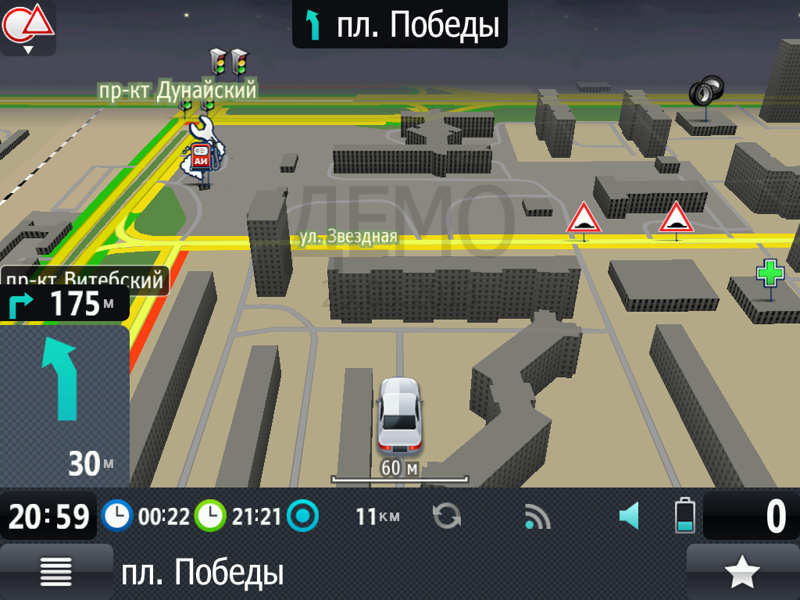
During the first launch after installation, the program will immediately prompt users to proceed to download the necessary cards terrain that is only possible with an Internet connection. Next, you will need to wait until the download completes, after which the application will automatically open the navigation section. The program boasts high-quality world animation, clear textures and high data accuracy. This means that each building will be displayed where it actually is.
Characteristic
The main task of any navigator is to compile optimal route, which PROGOROD copes with very well. It will plot the ideal route from point A to point B, taking into account absolutely all traffic congestion, which will allow the driver to get to his destination in the shortest possible time. The “traffic” algorithm carefully analyzes the speed of vehicles, taking into account existing traffic difficulties, thereby calculating the optimal speed of movement on a particular street. Thanks to this navigator the driver will be aware in advance of what is really happening on the road. At the same time, information about congestion can be obtained from the entire territory covered by the maps.
This car navigator will not allow the driver to get lost in various cities of the world. If you download PROGOROD for Android for free, you can confidently drive not only in Russia or Belarus, but also in Spain, the United Arab Emirates and other countries. The app's map catalog is constantly expanding, and useful functions there is already enough in it.
Features and Features
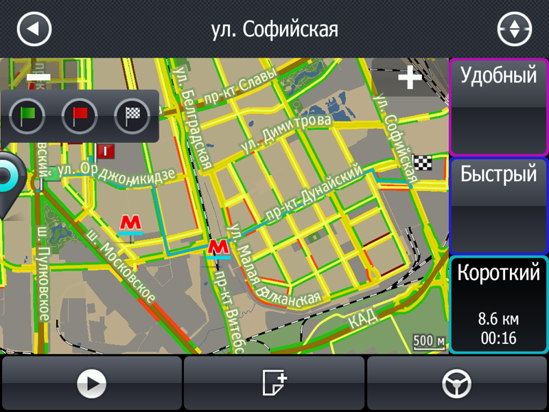
Choosing the optimal route– the application offers three route options to choose from. The user chooses from them the one that best suits his plans. The navigator accompanies the driver along the route, suggesting where and when to turn so as not to get lost.

Gesture control and voice input– it’s worth downloading PROGOROD for Android if only because of the ability to specify the end and start points of the route by voice. If desired, the driver can use his voice. The app also supports gesture controls.
Using maps offline– PROCITY navigation includes in its database maps of more than 120 thousand cities around the world. They are available to users without an Internet connection. The application updates information about traffic jams daily and uses it to determine coordinates GPS systems and GLONASS to build the best routes.
The navigator can also display maps in 3D mode, warns about dangerous road situations, uses a radar detector system and has other useful functions.
Ease of use and design
PROGOROD navigation is an easy-to-use application with a modern, eye-catching design. The settings are not confusing, the maps are clear and informative, and support 3D display. The application can work offline; a constant Internet connection is required only for the “Traffic” service.

Paid content
PROGOROD can be downloaded for Android for free using the link below. After installing the navigator, the trial period will begin for 30 days. At the end of this period the user will have to purchase full version program, which is this moment costs 1390 rubles.
In today's review we will talk about the Progorod navigation application, a worthy alternative to Yandex.Navigator and Navitel.
It is immediately worth noting the distribution conditions. “Progorod” costs 1,129 rubles, but during the first month you can use the application for free (with full functionality) and decide for yourself whether a purchase is necessary at all.
“Progorod” works offline - on the one hand, it does not require an Internet connection and, accordingly, does not consume traffic; on the other hand, it takes up a lot of space on internal memory devices. However, the user is given a choice - at the first start, Progorod offers to download the necessary regions, and then you can always download something additional. Each set of cards takes approximately 20 to 5500 megabytes; there are 16 states here (both some CIS countries and non-CIS countries like the USA). Russia is conveniently divided into regions - accordingly, in everyday life I only need the Northwestern Federal District.
The cards themselves, perhaps, would like to be called some fanciful positive epithet. Firstly, they are very detailed - right down to building 3D models of houses, taking into account the number of floors. This allows you to better navigate while driving when using the panoramic mode - roughly speaking, compare the picture on the display with the view behind the windshield. Secondly, there are no problems with relevance - the layers are periodically updated, so new roads appear digitally quickly. For example, Google.Maps is still not aware that the Western High-Speed Diameter was opened in St. Petersburg at the end of autumn. “Progorod” is aware of such important things.
![]()
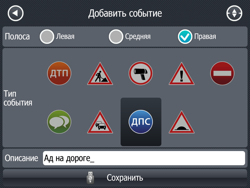
In addition, the application knows the location of numerous gas stations, pharmacies, car services, car washes and other points important for the motorist. Of course, the database of establishments cannot be called realistically complete, but within a radius of a kilometer or two you can always find something you need. Users can also add their own events/points, for example, cameras, traffic police posts or repair work.
Of course, Progorod also knows about the state of traffic jams at the current minute - for this, the application works with the Megafon traffic police network (or rather, with data on its congestion). Route planning is carried out in three options: “convenient”, “fast” and “short”. The program tries to analyze the intensity of congestion, the number of traffic lights and other details.
I tried several well-known directions and paths - in principle, “Progorod” thinks mostly correctly and does not try to send the driver along a guaranteed “standing” street or, say, against one-way traffic. There is also a comparative analysis of routes - sometimes the application considers that it is more reasonable to stand in a traffic jam for 15 minutes than to make a detour of 30 kilometers. True, like other navigation software, this program really doesn't like freeways. As you know, it is often much easier to get onto the Ring Road or other highways; Yes, it is much longer in distance, but without traffic lights and at high speed. Although you can set an imperative for “Progorod” to go through such and such a point.
Well, the only and most serious drawback in terms of functionality is the lack voice search. There is nothing special to comment on here; compared to the free Yandex.Navigator, this is a very serious disadvantage.
The interface is traditional and clearly looks like the usual car navigators. Huge buttons (for, perhaps, too big; for - normal) and characteristic “slowness” (not critical). Map details can be turned off to improve performance - without building windows, road outlines and some other elements, Progorod accelerates sharply. The skin can be changed in the settings (there are several color schemes) and depending on the time of day.

But still for iOS devices appearance I would like to see the applications a little more elegant - after all, Apple gadgets are accustomed to a little differently - but that’s all navigation programs as if they were deliberately being deliberately rude. Well, why leave huge buttons for changing the map angle and zooming on devices with a multi-touch screen? This is a clear rudiment from navigators with a resistive display; in a serious application, for 40 bucks it would be possible to finish such things.
While driving around the city, Progorod warns (by voice or sign) about radars, accidents and other troubles on the road 300, 700 and 1000 meters away. Optionally, you can set an alert when exceeding 20 km/h or 55 km/h. It is not clear why there is no 35 km/h - in my opinion, this is the most logical option; This is the maximum value with a relatively small penalty.
To work with traffic jams, the application requires that the device send its own data.
Another pleasant point is the presence personal statistics– “Progorod” remembers all routes and created warnings. The history is available both in a separate menu item and in the search window for the desired points, which is convenient.
* * * In fact, apart from the traditionally archaic interface for such applications and the lack of voice commands, Progorod is a very good thing. It’s not even interesting to compare with Navitel - the latter has fewer parts and stronger “brakes”. Comparison with Yandex.Navigator is already more complicated - it has a free price, a much more sane web interface, and the ability to work naked. But Progorod still has best card and quite adequate route algorithms.
Download, use it for a month and decide whether it’s worth 1129 rubles or you can get by with “YAN”.
Beschreibung mit Google Übersetzer in Deutsch übersetzen? Beschreibung in Russian zurückübersetzen
PROGOROD car navigation is not only maps and routing around the world, independent of the Internet, but also an opportunity to save on gasoline, car maintenance and services, as well as on some categories of goods. Install PROGOROD and, thanks to our partners, you will receive discounts on fuel, auto parts, tire service, towing and much more.
More than a million drivers already use the PROGOROD car navigator!
Traffic jams and speed cameras will no longer take you by surprise. Complex junctions are clear and simple with our realistic intersection images.
You don't need the Internet to use PROGOROD navigation! A connection will only be required if you are using the traffic jam service, but here too we have minimized traffic usage.
You can download the navigation and use all the functionality of the program completely free for 10 days, and upon registration - another 20!
Maps of Russia and more than 60 countries of the world are always available to you for FREE directly in the application.
If you do not have space on your device, you can use online maps of Russia, but we recommend downloading maps of your region to be able to use navigation in any conditions.
The map of Russia is updated daily!
The list of available world maps from the OpenStreetMap project is constantly expanding: Ukraine, Belarus, Kazakhstan, USA, Latvia, Lithuania, Estonia, Finland, Austria, Bulgaria, Hungary, Germany, Greece, Spain, Italy, Cyprus, Moldova, UAE, Saudi Arabia, Bahrain , Qatar, Kuwait, Oman, Poland, Romania, Slovakia, Turkey, Croatia, Czech Republic, Switzerland, France, Russia and other countries can be downloaded from the “Maps” menu in the application or from the website http://www.pro-gorod. ru.
Main functions of PROGOROD:
- Using maps without the Internet;
- Three route options with the ability to set intermediate points;
- Voice input and system keyboard;
- Indication of traffic lanes on the road;
- Daily routing updates through dynamic map adjustments;
- Warnings about speed cameras, speed bumps, pedestrian crossings and much more;
- 3D map display mode with houses close to reality;
- The “Radar Detector” screen shows maneuvers along the route and warns about cameras, speed bumps, dangerous intersections, etc.;
- “HUD” (Head-Up Display) - screen for projection onto the windshield of a car important information along the route;
- Search for addresses, gas stations, shops, cafes and other objects;
- Program control using gestures;
- The Geoblogs service will warn about dangers on the road;
- Taking into account the traffic situation (traffic jams) when constructing routes.
- End-to-end routing between countries.
- Profitable affiliate programs.
- Free call directly from the program in VOSEP (All-Russian Operational Emergency Service for Victims of Road Accidents).
User support: [email protected]
Join the PROGOROD user community:
VKontakte http://vk.com/club24014731
Operators mobile communications may charge a fee according to your tariff plan, for using the data network when using the "TRAFFIC" service.
Auto-Navigationssystem PROGOROD - ist nicht nur eine Karte und Routing auf der ganzen Welt, die sich auf die Verfügbarkeit des Internets hängt nicht, sondern auch die Möglichkeit, auf Benzin zu sparen, Fahrzeugwartung und Service sowie auf einige Kategorien von Waren. Installieren Sie PROGOROD und dank unseren Partnern werden Sie Rabatte für Treibstoff, Ersatzteile, Reifen-Service, Evakuierung und mehr erhalten.
Mehr als eine Million Fahrer sind bereits mit den Navigator PROGOROD!
Staus und Blitzer Sie nicht mehr erhalten rumpelt. Komplexe Umsteigemöglichkeiten klar und einfach mit unseren realistischen Bildern von Kreuzungen.
So verwenden Sie die Navigation PROGOROD nicht auf das Internet benötigen! Verbindung nur erforderlich, im Falle von Staus Dienst, aber hier haben wir die Verwendung von Datenverkehr minimiert.
Sie können die Navigation und die Nutzung aller Funktionen des Programms kostenfrei 10 Tage herunterladen, die Registrierung - 20 mehr!
Für Sie sind kostenlos Karten von Russland und mehr als 60 Ländern auf der ganzen Welt direkt in der App immer zur Verfügung.
Wenn Sie nicht auf Ihr Gerät haben, können Sie die Online-Karten von Russland verwenden, aber wir empfehlen, die Karte von der Region, in der Lage zu sein, die Vorteile der Navigation unter allen Bedingungen zu übernehmen.
Russland Karte wird täglich aktualisiert!
Die Liste der verfügbaren Weltkarten aus dem Projekt OpenStreetMap wird ständig erweitert: die Ukraine, Weißrussland, Kasachstan, den USA, Lettland, Litauen, Estland, Finnland, Österreich, Bulgarien, Ungarn, Deutschland, Griechenland, Spanien, Italien, Zypern, Moldawien ,Vereinigte Arabische Emirate, Saudi-Arabien, Bahrain //www.pro-gorod: Qatar, Kuwait, Oman, Polen, Rumänien, der Slowakei, der Türkei, Kroatien, Tschechien, der Schweiz, Frankreich, Russland und anderen Ländern können aus dem "maps " Menü in der Anwendung oder von der Website http heruntergeladen werden. ru.
Grundfunktionen PROGOROD:
- Verwendung der Karte ohne das Internet;
- Drei Varianten der Route mit der Möglichkeit Zwischenpunkten anzubringen;
- Spracheingabe und Systemtastatur;
- Anzeige der Fahrspuren auf der Straße;
- Tägliche Updates über das dynamische Routing Anpassungen Karten;
- Warnungen über Radarfallen, Geschwindigkeitsbegrenzungen, Fußgängerüberwege und vieles mehr;
- 3D-Display-Modus Karte mit Gebäuden nahe an der Realität;
- Screen "Antiradar" zeigt die Route Manöver und warnt vor den Kameras, Geschwindigkeitsbegrenzungen, gefährliche Kreuzungen, etc.,.
- “HUD” (Head-Up Display) - Bildschirm für die Projektion auf der Windschutzscheibe des Autos wichtiger Informationen entlang der Strecke;
- Suchen nach Adressen, Tankstellen, Geschäfte, Cafés und anderen Einrichtungen;
- Verwaltung des Programms mit dem Einsatz von Gesten;
- Service-Geoblogi warnen vor den Gefahren auf der Straße;
- Berücksichtigung der Verkehrssituation (Staus) die auf der Route.
- Der Pass-Through-Routing zwischen den Ländern.
- Profitable Affiliate-Programme.
- Gratis Anruf direkt aus dem Programm in VOSEP (Allrussische operativ-Stunden-Notfall-Hilfe für die Opfer von Verkehrsunfällen).
User Support: [email protected]
Der Community beitreten PROGOROD Benutzer:
Facebook http://www.facebook.com/pages/PROGOROD/241633452526114
Twitter http://www.twitter.com/progorod
VKontakte http://vk.com/club24014731
Mobilfunkbetreiber können nach Ihrem Tarif Plan für die Nutzung des Datennetzes berechnen, wenn Sie den Dienst "Stau" verwenden.